Advancements in technology have revolutionized various industries, and the field of aerial mapping is no exception. With the help of drones, it is now possible to create detailed 3D maps of any terrain or structure, providing invaluable data for a wide range of applications.
Using a drone for 3D mapping offers several advantages over traditional methods. Firstly, the drone can capture high-resolution images from a bird’s-eye view, allowing for a comprehensive view of the area. Additionally, drones equipped with specialized cameras can capture data such as topographical information and structural measurements, which are crucial for accurate mapping.
Getting started with 3D mapping using a drone may seem daunting, but with the right tools and techniques, it can be a straightforward process. The first step is to select the appropriate drone and camera. It is important to choose a drone that has a stable flight capability and a high-quality camera that can capture clear images.
Once you have the necessary equipment, the next step is to plan your flight path. This involves determining the area you want to map and creating a flight plan that ensures complete coverage. It is important to consider factors such as altitude, overlap between images, and flight speed to ensure accurate and detailed mapping results.
During the flight, the drone will capture a series of images or videos of the area of interest. These images are then processed using specialized software to create a 3D model. The software uses algorithms to stitch the images together and calculate the spatial information, resulting in a detailed and accurate 3D map.

3D mapping with a drone has numerous applications across various industries. It can be used in urban planning, land surveying, construction, environmental monitoring, and even in the entertainment industry. The ability to quickly and accurately create 3D maps provides valuable insights and facilitates better decision-making in these fields.
In conclusion, using a drone for 3D mapping offers a powerful tool for capturing detailed and accurate spatial information. By following the right techniques and utilizing the appropriate equipment, anyone can leverage the capabilities of a drone to create impressive 3D maps that serve various purposes.
What is 3D Mapping?
3D mapping, also known as photogrammetry or remote sensing, is a process of creating three-dimensional representations of objects or landscapes using aerial or ground-based imagery. By capturing multiple images of a scene from different angles, a 3D model can be generated, providing a realistic and accurate representation of the environment.
3D mapping with a drone involves using an unmanned aerial vehicle (UAV) equipped with a camera or sensor to capture images or data of the target area. These images or data are then processed using specialized software to reconstruct the 3D model. Drones are particularly well-suited for 3D mapping due to their maneuverability, ability to capture high-resolution images, and accessibility to remote or hard-to-reach areas.
The applications of 3D mapping are diverse and expanding, with uses in industries such as construction, agriculture, mining, urban planning, archaeology, and more. With 3D mapping, professionals can accurately measure distances, volumes, and heights, analyze terrain and structures, monitor vegetation growth, assess damage or changes over time, and even simulate scenarios for planning and decision-making.

Overall, 3D mapping with a drone provides a cost-effective, efficient, and precise method for capturing and analyzing spatial data. It allows for better visualization, interpretation, and understanding of the environment, leading to improved decision-making, resource management, and problem-solving.
The benefits of using a drone for 3D mapping
Using a drone for 3D mapping offers a range of benefits, making it a popular choice for surveyors, architects, and other professionals. Here are some key advantages:
- Efficiency: Drones can quickly capture and process large amounts of data, allowing for faster mapping and surveying compared to traditional methods. This increased efficiency saves time and resources.
- Precision: Drones equipped with GPS, cameras, and other sensors can capture detailed and accurate data, resulting in high-quality 3D maps. This precision is crucial for applications such as land surveying or construction planning.
- Safety: By using a drone, professionals can avoid potentially hazardous environments or difficult terrain, reducing the risk of accidents or injuries. Drones can access areas that would be challenging or dangerous for human surveyors.
- Coverage: Drones can cover large areas and capture data from different angles and perspectives. This comprehensive coverage allows for a detailed and thorough analysis of the terrain, buildings, or infrastructure being mapped.
- Cost-effectiveness: Compared to traditional mapping methods that involve manned aircraft or ground-based surveying teams, using a drone for 3D mapping is often more cost-effective. Drones are a relatively affordable solution that requires minimal resources for operation.
- Data visualization: With the help of specialized software, the data collected by drones can be transformed into interactive 3D models, visualizations, and maps. This allows stakeholders to easily understand and analyze the captured data, improving decision-making processes.
In conclusion, drones offer numerous benefits for 3D mapping and surveying applications. The combination of efficiency, precision, safety, coverage, cost-effectiveness, and data visualization makes drones a valuable tool for professionals in various industries.
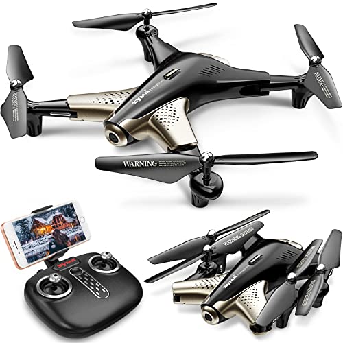
Step 1: Choosing the right drone
When it comes to performing 3D mapping with a drone, selecting the right drone is crucial. It’s essential to choose a drone that is capable of capturing high-quality aerial images and has the necessary features for 3D mapping.
Here are some factors to consider when selecting a drone:

- Camera quality: Opt for a drone with a high-resolution camera capable of capturing clear and detailed images. Look for drones that offer features like automated exposure settings and the ability to shoot in RAW format for better post-processing.
- Flight time: Consider a drone with a long flight time to ensure that you can cover a significant area without needing to recharge or swap batteries frequently.
- Stability and maneuverability: Look for a drone that offers stability and smooth flight controls. It should be able to withstand different weather conditions and perform precise maneuvers to capture accurate data.
- GPS and navigation: Drones equipped with GPS and advanced navigation systems can enable precise mapping and waypoint navigation, ensuring accurate data collection.
- Compatibility: Ensure that the drone you choose is compatible with the 3D mapping software you intend to use. Integration between the drone and software is essential for efficient data processing.
By carefully considering these factors, you can select a drone that meets your specific requirements for 3D mapping, enabling you to capture high-quality data for your mapping projects.
Step 2: Setting up the drone for 3D mapping
Before you begin 3D mapping with your drone, it’s important to properly set it up to ensure accurate and high-quality results. Follow these steps to get your drone ready for the mapping process:
1. Update firmware and software
Make sure that both your drone’s firmware and the accompanying mapping software are up to date. This will ensure that you have access to the latest features and improvements, as well as any bug fixes that may have been released.
2. Configure camera settings
Adjust the camera settings on your drone to optimize them for 3D mapping. Set the camera to capture images in high resolution and with appropriate exposure settings to provide clear and detailed images. Additionally, if your drone supports it, consider enabling any image stabilization features to reduce blurriness.
3. Calibrate sensors
Accurate sensor calibration is crucial for producing accurate 3D maps. Follow the manufacturer’s instructions to calibrate the drone’s accelerometer, gyroscope, and compass. This will ensure that the drone can accurately measure its position and orientation in space.

4. Plan your flight path
Prior to launching the drone, plan out the flight path that the drone will follow during the mapping process. Ensure that the path covers the desired area and includes overlapping images to facilitate the creation of a detailed 3D model.
5. Evaluate weather conditions
Before taking off, assess the weather conditions to ensure that they are suitable for drone mapping. Avoid flying in strong winds, rain, or low-light conditions, as these can negatively impact the quality of the images and the stability of the drone.
- Check wind speed and direction
- Ensure good visibility
- Avoid strong sunlight that can cause shadows
By following these steps, you will have your drone properly set up for 3D mapping and increase the chances of obtaining accurate and high-quality results.
Step 3: Planning the flight path
Before you can start 3D mapping with your drone, it is important to carefully plan your flight path. This will ensure that you capture the necessary images and data for an accurate and detailed 3D map.
Here are the key steps to consider when planning your flight path:

- Determine the area to be mapped: Identify the specific area that you want to map. This could be a construction site, a landscape, or any other location that requires mapping.
- Consider the weather conditions: Check the weather forecast to ensure that you fly your drone in suitable conditions. Avoid flying in strong winds, rain, or fog, as these can affect the quality of the images and the accuracy of the map.
- Study the terrain: Familiarize yourself with the terrain of the area to be mapped. This will help you understand any potential obstacles or challenges that may arise during the flight. Take note of any trees, buildings, or other structures that could obstruct the drone’s flight path or affect the mapping process.
- Select the flight parameters: Determine the altitude, speed, and overlap needed for capturing the images. Higher altitudes can provide a broader perspective, but may result in lower resolution images. Faster speeds can cover larger areas, but may lead to less detailed images. Overlap is important to ensure that the images can be stitched together accurately.
- Plot the flight path: Use mapping software or apps to plot the flight path for your drone. This will allow you to define the exact waypoints and routes that the drone should follow during the flight. Ensure that the flight path covers the entire area of interest and accounts for any obstacles or no-fly zones.
- Perform a pre-flight check: Before launching the drone, make sure to conduct a thorough pre-flight check. This includes checking the battery level, ensuring the propellers are properly attached, and verifying that the camera is working correctly.
By carefully planning your flight path, you can maximize the efficiency and effectiveness of your 3D mapping project. Take the time to consider all the necessary factors and prepare accordingly, and you’ll be well on your way to creating high-quality 3D maps with your drone.
Step 4: Collecting the data
Once you have planned your flight path and prepared your drone, it’s time to collect the data that will be used for creating the 3D map. Here are the steps to follow:
- Power on your drone and ensure that it is connected to the remote control and GPS.
- Double-check the camera settings to ensure they are optimal for capturing the necessary details.
- Make sure the memory card has enough storage space for the entire flight.
- Find an open area with clear skies and minimal obstructions.
- Begin the flight and follow the planned path, ensuring the drone captures images and video of the desired locations.
- Monitor the drone’s battery level and return to the starting point if it becomes critically low.
- Once the flight is complete, land the drone safely and power it off.
- Transfer the data from the drone’s memory card to your computer for processing.
It’s important to note that weather conditions can affect the quality of the data, so it’s best to avoid flying in strong winds, rain, or poor lighting conditions. Additionally, ensure that you comply with all local laws and regulations regarding drone usage and privacy.
Tips for successful data collection:
1. Plan your flight path carefully: Take into consideration the area you want to map and plan a flight path that covers it completely, ensuring there is sufficient overlap between the images for accurate mapping.
2. Use GPS waypoints: Utilize the drone’s built-in GPS capabilities to set waypoints along your flight path. This will help ensure accurate positioning and smoother flight navigation.

3. Test and calibrate: Before collecting the actual data, it’s recommended to perform test flights to ensure that the drone and camera settings are calibrated correctly. This will help minimize errors in data collection.
By following these steps and tips, you can effectively collect the data needed for 3D mapping with a drone.
Step 5: Processing the data
After capturing the aerial images and videos using the drone, the next step is to process the data to create a 3D map. Here are the steps to follow:
- Organize the data: Start by organizing and labeling your data to make it easier to work with. Create folders for each flight mission and store all the relevant images and videos together. This will help ensure that you have all the necessary data and can easily access it when needed.
- Choose the right software: There are several software options available for processing drone data and creating 3D maps. Some popular choices include Pix4D, DroneDeploy, and Agisoft Metashape. Research and choose the software that best fits your needs and budget.
- Import the data: Open the chosen software and import the aerial images and videos into the program. Make sure to follow the software’s guidelines for importing the data to ensure accuracy and optimal results.
- Align the images: The software will automatically align the images based on common points and features. This step is crucial for creating an accurate 3D map. Review the alignment results to ensure everything looks correct.
- Generate the 3D map: Once the images are aligned, the software will generate a 3D map using advanced photogrammetry techniques. This process may take some time depending on the complexity of the map and the power of your computer.
- Refine the map: After generating the initial 3D map, you may need to refine it by removing any unwanted objects or improving the details. Most software options provide tools for editing and refining the map to suit your specific requirements.
- Export the final map: Once you are satisfied with the 3D map, you can export it in various formats, such as OBJ or GeoTIFF, depending on your needs. These formats are commonly used for further analysis or visualization in other software or platforms.
Remember that processing drone data and creating a 3D map requires a certain level of expertise and understanding of the software. It may take some time and practice to achieve the desired results, but with patience and persistence, you can create accurate and detailed 3D maps using a drone.
Step 6: Creating the 3D model
Now that you have captured all the necessary aerial images, it’s time to transform them into a 3D model. This process involves using specialized software that can analyze the overlapping images and create a cohesive three-dimensional representation.
The first step in creating the 3D model is to import the aerial images into the software. Make sure to organize the images in the correct order and align them properly. The software will use the overlapping features in the images to stitch them together and generate a seamless model.
1. Image processing
Once the images are imported, the software will perform an initial processing stage to align and optimize the images. It will identify common features in the images and use them as reference points to create the 3D model.
The software will also remove any distortions or anomalies caused by factors such as lens distortion or vibrations during the flight. This is crucial for achieving accurate and precise results.
2. Point cloud generation
After the initial processing, the software will generate a point cloud from the aligned images. A point cloud is a collection of points in 3D space that represent the surface of the objects or terrain captured in the aerial images.
Using advanced algorithms, the software will estimate the position of each point based on the overlapping features in the images. This creates a dense and detailed point cloud that accurately represents the captured area.
Once the point cloud is generated, you can visualize and manipulate it in the software. You can rotate, zoom, or navigate through the 3D model to inspect and analyze the captured data.
Additionally, you can apply different rendering techniques to enhance the visualization of the 3D model. This includes applying textures to the 3D points to make the surfaces look more realistic and lifelike.
By creating a 3D model, you can gain valuable insights into the environment or object being mapped. This data can be used for various applications, such as urban planning, construction site monitoring, or virtual reality experiences.
Once you are satisfied with the 3D model, you can export it in a suitable format for further analysis or visualization in other software packages.
Step 7: Analyzing the 3D Model
Once you have successfully generated a 3D model of your mapping area using the drone, it’s time to analyze the model and extract valuable information from it. Here are some steps to follow:
| 1. Visual Inspection | Start by visually inspecting the 3D model to get an overall understanding of the mapping area. Look for any anomalies or objects that might affect your analysis. |
| 2. Measurements | Use the measurement tools provided by your 3D modeling software to take accurate measurements of distances, areas, and volumes within the model. This data can be useful for various applications like land surveying or construction planning. |
| 3. Comparison | If you have a reference model or survey data, compare it with your 3D model to identify any discrepancies or changes that might have occurred. This can help detect areas that need further investigation or monitoring. |
| 4. Feature Extraction | Extract specific features from the 3D model that are relevant to your project. This can include building footprints, road networks, vegetation density, or any other objects that are of interest. Various software tools are available for automated feature extraction. |
| 5. Data Analysis | Perform statistical analysis or data mining techniques on the extracted features to gain deeper insights into the mapping area. This can help identify patterns, trends, or anomalies that might not be visible through visual inspection alone. |
By following these steps, you can make the most of your 3D model and use it for various applications like urban planning, environmental monitoring, or asset management.
Step 8: Using the 3D map for various purposes
Once you have successfully generated a 3D map using your drone and mapping software, you can utilize it for various purposes. This section will outline some of the most common applications of 3D maps:
1. Urban planning and development:
With the help of 3D mapping, urban planners can accurately visualize and analyze the existing infrastructure of a city or region. This can aid in identifying areas for potential development, assessing the impact of projects, and making informed decisions about land use and zoning. The detailed 3D model can also be used to simulate and evaluate the effects of proposed changes on traffic patterns, aesthetics, and overall cityscape.
2. Environmental conservation and management:
3D mapping can be a valuable tool for environmental scientists and conservationists. It allows them to monitor and assess the health of ecosystems, track changes over time, and identify potential threats. By creating detailed 3D models of natural areas, researchers can analyze vegetation density, measure the height of trees, and identify potential habitat corridors. This information can then be used to develop effective conservation strategies and prioritize areas for protection.
3. Archaeological research and exploration:
Archaeologists can benefit greatly from using 3D maps to document and study ancient sites. By capturing high-resolution images and creating detailed models of archaeological sites, researchers can make accurate measurements, analyze the spatial relationships between artifacts, and preserve the site digitally. This technology has the potential to revolutionize archaeological research by providing a non-invasive method of documentation and analysis.
In addition to these applications, 3D mapping can also be used in fields such as construction, real estate, forestry, disaster management, and more. The possibilities are endless, and the technology is constantly evolving.
Remember to always comply with local regulations and privacy laws when using drones for mapping purposes.
Question-answer:
What is 3D mapping with a drone?
3D mapping with a drone is a process of creating detailed, three-dimensional models of a specific area using a drone equipped with various sensors and cameras. The drone collects a large number of images or videos, which are then processed using specialized software to generate a highly accurate 3D model of the area.
What are the applications of 3D mapping with a drone?
There are various applications of 3D mapping with a drone. It can be used in urban planning to create accurate models of cities, in agriculture to monitor crop health and plan irrigation, in construction to monitor progress and detect potential issues, in archaeology to create detailed maps of historical sites, and in many other fields where accurate and detailed 3D models are required.
What equipment do I need to do 3D mapping with a drone?
To do 3D mapping with a drone, you will need a drone equipped with a high-resolution camera or a camera capable of capturing images at regular intervals. In addition, you may need other sensors such as lidar or thermal cameras depending on the specific requirements of your project. Finally, you will need a computer with specialized software to process the collected data and create the 3D models.
Is it difficult to learn how to do 3D mapping with a drone?
Learning how to do 3D mapping with a drone can be a bit challenging at first, especially if you have no prior experience with drones or mapping software. However, there are many resources available, including online tutorials and courses, that can help you learn the necessary skills. With practice and dedication, you can become proficient in 3D mapping with a drone.