
Drones have revolutionized many industries, and mapping is no exception. With a drone, you can quickly and accurately create detailed maps and 3D models of landscapes, buildings, and other areas. This technology has opened up new possibilities for professionals in fields such as surveying, urban planning, agriculture, and more. If you’re interested in learning how to map with a drone, this guide will provide you with the essential steps to get started.
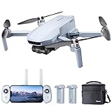
1. Choose the right drone: When it comes to mapping, it’s important to select a drone that is specifically designed for this purpose. Look for a drone with a high-resolution camera, GPS capabilities, and a stable flight performance. These features will ensure that you capture accurate and detailed imagery for your maps.
2. Plan your flight: Before you take off, it’s crucial to plan your flight path. Determine the area you want to map and use drone mapping software to create a flight plan. This will help ensure that you capture the necessary data and cover the entire area efficiently. It’s also important to consider factors such as weather conditions and airspace regulations.
3. Capture the data: Once you’re in the air, it’s time to start capturing the data. Fly your drone in a controlled and systematic manner, ensuring that you have enough overlap between each photo or video capture. This overlap is essential for creating accurate maps and 3D models. Take multiple shots from different angles and altitudes to ensure comprehensive coverage of the area.
Benefits of Using Drones for Mapping
Drones, also known as unmanned aerial vehicles (UAVs), have revolutionized the field of mapping and surveying. With their ability to capture aerial imagery and data, drones offer a range of benefits for mapping projects.

1. Higher Accuracy and Detail
Using drones for mapping allows for higher accuracy and detail compared to traditional methods. Drones equipped with high-resolution cameras and sensors can capture detailed images and collect accurate data that can be used to create highly precise maps and models.
2. Increased Efficiency
Drones can significantly increase the efficiency of mapping projects. With their ability to cover large areas in a short amount of time, drones can collect data and capture images much faster than traditional ground-based methods. This can save time and resources, especially for projects that require extensive coverage.
3. Cost-effective Solution
Using drones for mapping can be a cost-effective solution compared to manned aircraft or ground-based surveys. Drones are relatively affordable and can be deployed quickly, eliminating the need for expensive equipment and lengthy setup times. This makes drones a more accessible option for mapping projects with limited budgets.
4. Enhanced Safety
Drones offer enhanced safety compared to traditional surveying methods. By eliminating the need for personnel to physically access hazardous or hard-to-reach areas, drones can reduce the risk of accidents and injuries. This is particularly beneficial for mapping projects in challenging terrain or areas with potential safety hazards.
5. Flexibility and Adaptability
Drones provide flexibility and adaptability in mapping projects. With their ability to fly at different altitudes and capture images from various angles, drones can be easily adjusted to meet specific project requirements. They can also be equipped with specialized sensors for collecting data on specific parameters, such as thermal imaging for environmental monitoring.

In conclusion, using drones for mapping offers numerous benefits, including higher accuracy, increased efficiency, cost-effectiveness, enhanced safety, and flexibility. As the technology continues to advance, drones are becoming an essential tool for mapping professionals seeking to optimize their data collection and analysis processes.
Choosing the Right Drone for Mapping
Mapping with a drone has become an increasingly popular method for capturing high-quality aerial imagery. However, to ensure the success of your mapping project, it is essential to choose the right drone for the job.
Consider the flight time: When selecting a drone for mapping purposes, it is crucial to consider the flight time. Mapping missions often require extended flight times to cover large areas accurately. Look for a drone with a long battery life or the ability to easily swap out batteries to minimize downtime.
Payload capacity: Another crucial factor to consider is the drone’s payload capacity. The payload capacity determines the weight of the camera or sensor equipment that the drone can carry. Make sure the drone you choose can handle the weight of your mapping equipment without affecting flight stability.
Camera specifications: The quality of your mapping imagery heavily relies on the camera specifications of the drone. Look for a drone with a high-resolution camera that can capture detailed imagery. Additionally, consider features such as adjustable gimbal to ensure stable and smooth footage.
Flight modes and automation: Mapping projects often require repetitive flights and precise mapping patterns. Look for a drone that offers advanced flight modes and automation features, such as waypoint navigation and orbit mode. These features can streamline your mapping process and enhance the accuracy of your data collection.
Compatibility with mapping software: Lastly, consider the compatibility of the drone with the mapping software you plan to use. Ensure that the drone’s data can be easily integrated with the mapping software for efficient processing and analysis.
In conclusion, choosing the right drone for mapping involves considering factors such as flight time, payload capacity, camera specifications, flight modes, and compatibility with mapping software. By carefully selecting a drone that meets your mapping needs, you can ensure the success and accuracy of your mapping projects.
Understanding the Basics of Aerial Photography
Aerial photography has become increasingly popular with the rise of drone technology. Drones equipped with cameras allow photographers and mapping professionals to capture stunning aerial images for various purposes, including mapping landscapes, surveying areas, monitoring construction sites, and creating visual content.
Advantages of Aerial Photography
There are several advantages to using aerial photography for mapping and surveying:

- High-Quality Images: Aerial photography provides high-resolution images, allowing for detailed analysis and accurate mapping.
- Accessibility: Drones can access areas that are difficult to reach by foot or traditional ground-based photography methods, making it easier to capture images of remote or inaccessible landscapes.
- Cost-Effective: Aerial photography using drones is often more cost-effective than using manned aircraft or satellite imagery. It eliminates the need for helicopters or planes, reducing both the expenses and risks associated with traditional aerial photography.
- Real-Time Data: Drones can transmit images and data in real-time, enabling immediate analysis and decision-making.
Camera Equipment for Aerial Photography
The key to successful aerial photography is selecting the right camera equipment. Here are some factors to consider:
- Resolution: Choose a camera with a high resolution to capture detailed images.
- Lens: Select a lens suitable for aerial photography, such as wide-angle or zoom lenses.
- Stabilization: Ensure the camera or drone has stabilization capabilities, as the movement of the drone can affect image quality.
- Filters: Consider using filters to enhance image quality and reduce glare or reflections.
Tips for Aerial Photography
To achieve the best results in aerial photography, keep the following tips in mind:
- Plan Your Flight: Before flying, plan the flight path to ensure full coverage of the desired area.
- Consider Lighting Conditions: Lighting plays a crucial role in photography. Choose the optimal time of day with favorable lighting conditions.
- Experiment with Angles: Explore different angles and perspectives to capture unique aerial images.
- Be Mindful of Weather Conditions: Avoid flying in adverse weather conditions, such as strong winds or rain, as it may jeopardize the safety of the drone and image quality.
- Follow Applicable Regulations: Familiarize yourself with local drone regulations and fly responsibly within the legal boundaries.
By understanding the basics of aerial photography and following best practices, you can capture stunning aerial images for mapping and other purposes using drones.
Planning a Drone Mapping Mission
Before you start mapping with a drone, it is important to plan your mission carefully to ensure the best possible results. Here are some steps to consider when planning your drone mapping mission:
1. Define your goals: Determine what you want to achieve with your drone mapping mission. Whether it’s creating a topographic map, monitoring an area for changes, or conducting a survey, clearly define your goals so you can tailor your mission accordingly.

2. Choose the right equipment: Select a drone that is suitable for mapping. Look for features such as a high-quality camera, long flight time, and the ability to capture images in different formats. Additionally, ensure that you have the necessary accessories such as extra batteries and memory cards.
3. Research the area: Familiarize yourself with the area that you will be mapping. Identify any potential obstacles such as buildings, trees, or power lines that may interfere with your flight path. This information will help you plan your route and avoid accidents.
4. Check local regulations: Before flying your drone, make sure to check the local regulations and obtain any required permits or licenses. Some areas may have specific rules regarding drone flights, especially if you are planning to fly in urban or restricted airspace.
5. Plan your flight path: Determine the flight path that your drone will follow to capture the necessary imagery. Consider factors such as the altitude, overlap between images, and the area you need to cover. There are several software tools available that can help you plan your flight path efficiently.
6. Perform a pre-flight check: Before launching your drone, conduct a thorough pre-flight check to ensure that all components are functioning properly. Check the battery level, GPS signal, and camera settings to avoid any issues during the mapping mission.

7. Fly and capture images: Launch your drone and follow the planned flight path. Make sure to capture high-quality images by adjusting the camera settings and maintaining a stable flight. Consider capturing images from different angles or heights to get a comprehensive view of the area.
8. Post-processing: After completing the mapping mission, transfer the captured images to your computer and use specialized software to stitch them together and create a detailed map or model. Apply any necessary corrections or enhancements to ensure accurate and visually appealing results.
By following these steps and planning your drone mapping mission carefully, you can maximize the quality and accuracy of your mapping data.
Tips for Capturing High-Quality Aerial Images
When it comes to mapping with a drone, capturing high-quality aerial images is essential. These images serve as the foundation for creating accurate and detailed maps. Here are some tips to help you capture the best possible aerial images:
1. Plan your flight path: Before taking off, carefully plan your flight path to ensure complete coverage of the area you want to map. Use a mapping software or app to create a pre-defined flight plan that will optimize your image capture.

2. Fly at the right altitude: The altitude at which you fly will greatly impact the quality of your aerial images. Depending on the desired resolution and level of detail, adjust your flight altitude accordingly. Be aware of any local regulations and restrictions regarding drone flights.
3. Use a high-quality camera: Invest in a drone with a high-quality camera or attach a compatible camera to your drone. A higher megapixel count and image sensor size will result in sharper and more detailed images. Additionally, consider using a camera with manual settings to have more control over exposure and focus.
4. Choose the right time of day: The lighting conditions during your flight can greatly affect the quality of your aerial images. Early morning or late afternoon, when the sun is lower in the sky, can help create more even lighting and avoid harsh shadows. Avoid flying in strong sunlight, as it can cause overexposure and washed-out images.
5. Use the rule of thirds: Compose your aerial images using the rule of thirds to create a visually pleasing composition. Divide the frame into a 3×3 grid and place key points of interest or elements along the gridlines or at the intersection points. This will add depth and balance to your images.
6. Ensure proper focus: Pay attention to the focus of your aerial images. Use autofocus or manual focus to ensure that the important elements of your images are sharp and well-defined. Keep in mind that autofocus can sometimes struggle with distant objects, so manual focus might be necessary in such cases.
7. Capture overlapping images: To create accurate and detailed maps, capture overlapping images of the same area. This will help with image stitching and reduce any gaps or errors in the final map. Use an overlap of at least 60% between images to ensure proper coverage.
8. Avoid motion blur: To prevent motion blur in your aerial images, ensure that your drone is stable during the entire capture process. Avoid fast movements or abrupt changes in direction. Consider using a drone with advanced stabilization features or a gimbal for even smoother footage.
By following these tips, you can capture high-quality aerial images that will enable you to create accurate and detailed maps. Remember to always prioritize safety and adhere to any local regulations regarding drone flights.
Processing Drone Imagery with Photogrammetry Software
Once you have captured aerial imagery using a drone, the next step is to process the data to create accurate maps and 3D models. Photogrammetry software is used to stitch together the individual images and generate the final output.
There are several photogrammetry software options available, each with its own features and capabilities. Some popular choices include:
| Software | Features |
|---|---|
| Pix4Dmapper | Advanced image processing algorithms Automated stitching and georeferencing Accurate 3D modeling Compatibility with various drone platforms |
| Agisoft Metashape | Powerful photogrammetric engine Flexible workflow options Mesh generation and texturing Georeferencing capabilities |
| DJI Terra | Designed specifically for DJI drones Real-time mapping and analysis AI-powered algorithms Simple and intuitive interface |
| DroneDeploy | Cloud-based processing Automated flight planning and data capture Integrations with other GIS tools Highly customizable output options |
Once you have selected the photogrammetry software that best suits your needs, the next step is to import the drone imagery and define the parameters for processing. This may include specifying the image overlap, camera settings, and coordinate system.
The software will then analyze the images and identify common points or features in multiple images. It will use these points to calculate the position and orientation of the camera in each image, enabling it to create an accurate 3D model and orthomosaic.
The processing time will depend on the number and resolution of the images, as well as the complexity of the scene being mapped. Once the processing is complete, you can explore the 3D model, measure distances and volumes, and overlay other geospatial data for analysis.
Overall, photogrammetry software plays a crucial role in turning raw drone imagery into valuable maps and models. It enables professionals in various industries, such as surveying, agriculture, and construction, to gather accurate and detailed information that can inform decision-making and improve operations.
Creating Accurate and Detailed Maps with Drone Imagery
Why Use Drones for Mapping?
Drones have revolutionized the way we create maps by providing an efficient and cost-effective solution. With their ability to capture high-resolution aerial imagery and collect data from remote locations, drones have become an indispensable tool for creating accurate and detailed maps.
The Process of Mapping with Drones
The process of mapping with drones involves several key steps:
- Flight Planning: Before launching the drone, it is important to plan the flight path to ensure maximum coverage and accuracy. Modern drone software allows for easy flight planning and autopilot navigation.
- Image Capture: Drones are equipped with high-resolution cameras that capture aerial imagery at different angles and altitudes. These images are geotagged, allowing for accurate positioning and alignment during processing.
- Data Processing: The captured imagery is processed using specialized software to create maps. This involves stitching the images together, aligning them with GPS data, and applying photogrammetry techniques to create accurate 3D models.
- Analysis and Interpretation: Once the maps are created, they can be analyzed and interpreted to derive valuable insights. This can involve identifying land features, measuring distances and areas, and assessing changes over time.
The Benefits of Drone Mapping
Using drones for mapping has numerous benefits:
- Accuracy: Drones capture images with high resolution and high positional accuracy, resulting in maps that are more precise compared to traditional methods.
- Efficiency: Drones can cover large areas quickly and easily, reducing the time and effort required for mapping projects.
- Cost-effectiveness: Mapping with drones is often more cost-effective compared to traditional methods, as it eliminates the need for expensive equipment and labor-intensive fieldwork.
- Safety: Drones can access remote or hazardous areas, making it safer for surveyors and reducing the risk of accidents or injuries.
- Flexibility: Drones can be deployed in a variety of environments and terrains, making them versatile for different mapping projects.
Conclusion
Drone mapping offers a powerful and efficient solution for creating accurate and detailed maps. The use of drones allows for improved accuracy, efficiency, and cost-effectiveness, while also enhancing safety and flexibility. By harnessing the power of drone imagery, mapping professionals can create maps that provide valuable insights for a wide range of applications.
Applications of Drone Mapping in Various Industries
Drone mapping has proven to be an invaluable tool in a wide range of industries. The use of drones equipped with mapping technology has revolutionized the way tasks are performed in these industries, providing more accurate and efficient data collection. Here are some key applications of drone mapping in various industries:
1. Agriculture
Drones equipped with mapping technology have greatly enhanced agriculture practices. They can be used to monitor crops, assess crop health, and identify areas that require intervention. The data collected by drones can help farmers optimize irrigation, fertilization, and pest control, resulting in increased yields and reduced costs.
2. Construction and Real Estate
In the construction and real estate industries, drones have become essential tools for surveying and mapping areas. Drones can create detailed aerial maps, 3D models, and topographic data of construction sites and properties. This information is crucial for site planning, architectural design, and property evaluation.
3. Environmental Conservation
Drone mapping is widely used in environmental conservation efforts. Drones can be deployed to monitor and map ecosystems, track changes in land use, and detect illegal activities such as deforestation and poaching. The collected data helps conservation organizations make informed decisions regarding habitat preservation and wildlife protection.
4. Infrastructure Inspection
Using drones for infrastructure inspection has proven to be safer, faster, and more cost-effective compared to traditional methods. Drones equipped with high-resolution cameras or thermal imaging sensors can inspect bridges, pipelines, power lines, and other infrastructure for damage, wear and tear, or potential hazards without the need for manual inspections.
5. Mining
Drone mapping is extensively used in the mining industry for surveying and mapping large areas. Drones can quickly and accurately collect data on topography, volume measurements, and geological formations. This information is vital for mine planning, resource estimation, and environmental impact assessment.
6. Search and Rescue
Drone mapping plays a crucial role in search and rescue operations. Drones equipped with thermal cameras and real-time mapping capabilities can quickly locate missing persons or survivors in disaster-stricken areas. The data collected by drones helps rescue teams plan their operations more effectively and increases the chances of a successful outcome.
These are just a few examples of the vast range of applications for drone mapping technology across various industries. As the technology continues to advance, we can expect drones to play an even greater role in improving efficiency, accuracy, and safety in these industries.
Question-answer:
What is drone mapping?
Drone mapping is the process of using a drone to create accurate and detailed maps of an area. The drone is equipped with a camera or other sensors that capture images or data, which is then processed to generate a map.
What are the benefits of using drones for mapping?
Using drones for mapping has several benefits. Firstly, drones can cover large areas quickly and efficiently, making them ideal for mapping large-scale projects. Secondly, drones can capture high-resolution images, allowing for detailed and accurate mapping. Lastly, using drones can be more cost-effective than traditional mapping methods.
What equipment do I need for drone mapping?
To get started with drone mapping, you will need a drone with a camera or other sensors, a remote control or mobile device to operate the drone, and mapping software to process the captured data and create maps. It’s also important to have spare batteries and memory cards, as well as a suitable case or bag to transport and protect your equipment.
Are there any legal restrictions for drone mapping?
Yes, there are legal restrictions for drone mapping. In most countries, drones are subject to aviation regulations and must be operated within certain limitations. These limitations usually include flying below a certain altitude, maintaining a line of sight with the drone, keeping away from airports and other sensitive areas, and obtaining the necessary permits or licenses for commercial drone operations.


